پَنٛجاب (ہِندوستان)
(پنجاب (ہِندوستان) پؠٹھٕ رُجوع مُکرَر)
پَنٛجاب چھُ شُمٲلؠ ہِندوستانَس مَنٛز اَکھ رِیاسَتھ۔[3]
پَنٛجاب | |
|---|---|
|
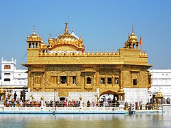
Clockwise from top : Golden Temple, Wagah border, Gobindgarh Fort, Punjabi Bhangra dance, Jallianwala Bagh memorial | |
| لَفظٕ آگُر: پَنٛج مَطلَب پٲنٛژھ آب مَطلَب پونؠ یا دٔرؠ یاو | |
 جائے پنجاب (ہِندوستان) | |
| Coordinates (Chandigarh): 30°47′N 75°50′E / 30.79°N 75.84°E | |
| مُلک | |
| رازدٲنؠ | چندی گڑھ |
| بوٚڈ شَہر | لُدھیانا |
| ضِلعہٕ | ۲۲ |
| حوٚکوٗمَتھ | |
| • اِدارٕ | پنجاب حَکومَت |
| رۄقبہٕ | |
| • مُکمَل | 50٬362 km2 (19٬445 sq mi) |
| رۄقبہٕ دَرجہِ | 19 یُم |
| آبٲدی (2011)[1] | |
| • مُکمَل | 27٬743٬338 |
| • Rank | ۱۶ |
| سَرکٲری زَبان | پنجابی[2] |
| ویبسایٖٹ | punjab |
حَوالہٕ
اؠڈِٹ- ↑ "Area, population, decennial growth rate and density for 2001 and 2011 at a glance for Punjab and the districts: provisional population totals paper 1 of 2011: Punjab". Registrar General & Census Commissioner, India. Archived from the original on 7 January 2012. Retrieved 26 January 2012.
- ↑ "Report of the Commissioner for linguistic minorities: 50th report (July 2012 to June 2013)" (PDF). Commissioner for Linguistic Minorities, Ministry of Minority Affairs, Government of India. Archived from the original (PDF) on 8 July 2016. Retrieved 4 December 2016. آرکایو کۆرمُت 8 جُلَے 2016 بذریعہ ویے بیک مَشیٖن "Archived copy" (PDF). Archived from the original (PDF) on 8 July 2016. Retrieved 2 August 2021.CS1 maint: archived copy as title (link) آرکایو کۆرمُت 8 جُلَے 2016 بذریعہ ویے بیک مَشیٖن"Archived copy" (PDF). Archived from the original (PDF) on 8 July 2016. Retrieved 2 August 2021.CS1 maint: archived copy as title (link) آرکایو کۆرمُت 8 جُلَے 2016 بذریعہ ویے بیک مَشیٖن
- ↑ "Punjab, India | History, Map, Culture, Religion, & Facts | Britannica". www.britannica.com ( اَنگیٖزؠ زَبانہِ مَنٛز). Retrieved 2022-06-06.


