فَیِل:Kashmir-sat-nasa.jpg
نُمٲشِہ ہُنٛد ناپ: 600 × 600 پِکسَل باقی ریزولوشَن: 240 × 240 پِکسَل | 480 × 480 پِکسَل | 640 × 640 پِکسَل
اَصلی فَیِل (640 × 640 پِکسَل، فَیِل ناپ: 428 کِلوبایِٹ، MIME قسٕم:image/jpeg)
خُلاصہٕ
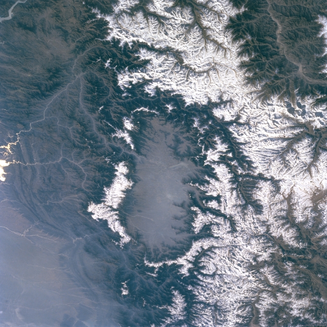
| تَفصیٖل | Kashmir Valley bordered by Karakorm Range in the north, Zanskar Range in the east and Pir Panjal Range in the west and south. |
| تٲریٖخ | before ٢ اَپریل ٢٠٠٩ |
| آگُر | http://eol.jsc.nasa.gov/sseop/EFS/images.pl?photo=STS066-127-79 |
| مُصَنِف | NASA |
اِجازَت نامہ:
| This file is in the public domain in the United States because it was solely created by NASA. NASA copyright policy states that "NASA material is not protected by copyright unless noted". (See Template:PD-USGov, NASA copyright policy page or JPL Image Use Policy.) | ||
 |
Warnings:
|
Original upload log
The original description page was here. All following user names refer to en.wikipedia.
- 2009-04-01 06:02 Doorvery far 640×640× (438485 bytes) Public domain nasa image: http://eol.jsc.nasa.gov/sseop/EFS/images.pl?photo=STS066-127-79
فَیِل تَوٲریٖخ
فَیِل وُچھنہٕ باپتھ کٔریو کلک تأریخ/وقت پؠٹھ تاکہِ یہ گژھِ تمہ وقتہٕ ظٲہر
| تٲریٖخ/وَقت | تھمب نیل | پہلوٗو | صٲرِف | کَتھ | |
|---|---|---|---|---|---|
| موجودٕ | 15:45, 17 مٔیی 2011 | | 640 × 640 (428 کِلوبایِٹ) | Woudloper | {{Information |Description={{en|Public domain NASA image: http://eol.jsc.nasa.gov/sseop/EFS/images.pl?photo=STS066-127-79}} |Source=Transferred from [http://en.wikipedia.org en.wikipedia] |Date={{Date|2009|04|01}} (original upload date) |Author=Original u |
فَیِلٕ ہُند اِستِعمال
یہِ صَفہٕ چھُ اَتھ فَیِلہِ اِستِمال کَران:
فَیِلہٕ ہُنٛد عالمِی اِستِمال
دِنہٕ آمٕتیٚو باقٕی وِکیٖیَن منٛز چھےٚ یہِ بٕہی استعمال سپدان:
- ar.wikipedia.org پؠٹھ استعمال
- be.wikipedia.org پؠٹھ استعمال
- bh.wikipedia.org پؠٹھ استعمال
- bn.wikipedia.org پؠٹھ استعمال
- de.wikipedia.org پؠٹھ استعمال
- de.wikivoyage.org پؠٹھ استعمال
- dty.wikipedia.org پؠٹھ استعمال
- en.wikipedia.org پؠٹھ استعمال
- en.wikivoyage.org پؠٹھ استعمال
- es.wikipedia.org پؠٹھ استعمال
- fa.wikipedia.org پؠٹھ استعمال
- frr.wikipedia.org پؠٹھ استعمال
- fr.wikipedia.org پؠٹھ استعمال
- fr.wikinews.org پؠٹھ استعمال
- fr.wikivoyage.org پؠٹھ استعمال
- gu.wikipedia.org پؠٹھ استعمال
- he.wikipedia.org پؠٹھ استعمال
- hi.wikipedia.org پؠٹھ استعمال
- id.wikipedia.org پؠٹھ استعمال
- ja.wikipedia.org پؠٹھ استعمال
- kn.wikipedia.org پؠٹھ استعمال
- ko.wikipedia.org پؠٹھ استعمال
- ml.wikipedia.org پؠٹھ استعمال
- mr.wikipedia.org پؠٹھ استعمال
- ms.wikipedia.org پؠٹھ استعمال
- ne.wikipedia.org پؠٹھ استعمال
- nl.wikipedia.org پؠٹھ استعمال
- nn.wikipedia.org پؠٹھ استعمال
- os.wikipedia.org پؠٹھ استعمال
- pa.wikipedia.org پؠٹھ استعمال
- pl.wikipedia.org پؠٹھ استعمال
- pnb.wikipedia.org پؠٹھ استعمال
- ru.wikipedia.org پؠٹھ استعمال
- ru.wikinews.org پؠٹھ استعمال
- sa.wikipedia.org پؠٹھ استعمال
- simple.wikipedia.org پؠٹھ استعمال
- sl.wikipedia.org پؠٹھ استعمال
View more global usage of this file.